
Petrophysics is a branch of Physics applied to Petroleum Exploration. To make the things be understood let me give an Introduction to the Petroleum Exploration. Suppose a vast area (on land or in sea) is to be explored from Hydrocarbon point of view. Satellite images are examined to find first order Topography. Topography is map with height. Small planes are flown over the area and photographs are taken. These are followed by Geophysical surveys, i.e Gravity and Magnetic surveys are done over the area to identify interesting features , specially Anticline Structures in the subsurface.
Then in the interesting areas Seismic survey is done. Here bombs are exploded on the surface and Sound waves travel down the subsurface, reflected back from subsurface layers and are recorded in Geophones on Land and in Hydrophones over sea.
At this stage a little Geological Structures deserve to be discussed. Petroleum is trapped normally in Anticline ( Dome like) structures and other Traps e.g Faults, Unconformity etc. So from Seismic survey we primarily search for Anticline structures , where petroleum might be trapped underground.
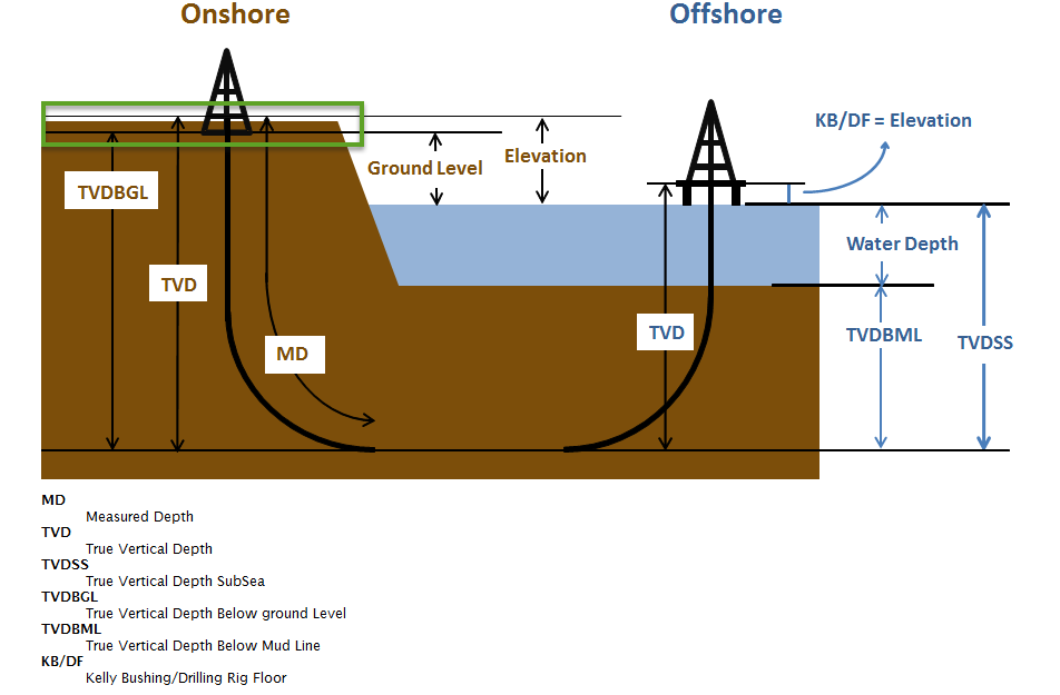
Normally in India we get petroleum at depths anywhere between 1000m to 5000m below the ground.
Then at the place where petroleum is most likely to have been trapped , a Well is Drilled.
Drilling is done with Mud (specially prepared) filled in it, to prevent well from being collapsed. The Diameter of the well is Telescopic, i.e may start with 22.25 inch or 17.5 inch and ends with 5.5 inch. The well is Cased with Iron Pipes and the annular space between formation and casing pipe is cemented.
Petrophysics
Now after a well is drilled, Petrophysicists go to the drill-site with a computerised Logging Unit and Petrophysical tools. These tools are lowered in the well with the help of Winch ( conducting cable wound on a drum) and Data of the Formations (earth layers) is recorded in a computer.
The tools are based on the principles of physics, Resistivity tools, Radioactive tools, Sonic tool, CMR tool , Dielectric tool, Dipmeter tool etc.
Principle of CMR tool is same as that of CT Scan instrument in hospitals. The electronics used in the tools are of same specifications as those used by NASA. All units and tools are imported from USA.
Normally most layers down-earth are basically Shales and do not contain hydrocarbon. Some of the layers are of Sandstones, which may contain hydrocarbons or water. In Offshore it is Limestone, which contain hydrocarbon.
Shales have low Resistivity. Sand stones have high Resistivity, if they contain hydrocarbon and low Resistivity, if contain water.
Petrophysical parameters , say Resistivity is presented against depth. This presentation is called LOG. There are many logs , which are recorded in one well. To confirm presence or absence of Hydrocarbon in a drilled well.
(to be continued…..)
Dr.GoutamMukhopadhyay, DOB 24.02.1954
B.Sc Physics Hons, Presidency College
M.Sc Physics C.U
Ph,d under Prof C.K.Majumadar, J.U
Diploma in Management from IGNOU
Joined ONGC in 1985, as Class I officer, as Petrophysicist
Retired in 2014
Served in data Acquisition , Processing and Interpretation
Visited Bogota, Colombia, in 2010 for data interpretation.
After retirement served ongc as domain expert, served Syntex oil as Consultant.
Delivered lectures on Petrophysics and other Petroleum subjects, Unconventional Energy,
Industrial Safety, Petroleum Refinery at different Institutes e.g MIT , Pune, ISM, Dhanbad,
RTU, Kota Rajasthan, SAL Institute , Ahmedabad, Petroleum Management University, Gandhinagar.
Last two years served Petroleum Department, Presidency University, Bangalore as Adjunct Faculty.


Comment here
You must be logged in to post a comment.